报告详情
Application of Dijkstra Algorithm in Path Planning for Geomagnetic Navigation
编号:151
访问权限:仅限参会人
更新:2020-08-05 10:17:28 浏览:657次
口头报告
摘要
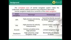
Path planning is one of the key technologies to realize the hidden navigation of underwater vehicles during long-haul. Path planning efficiency and accuracy are at the core of submarine track planning. Combining the navigation task with the geomagnetic map adaptability, the optimal path between the starting point and the target point is searched in the target space. The underwater geomagnetic navigation path planning model is established, and the principle and implementation method of Dijkstra algorithm are analyzed. An underwater geomagnetic navigation path planning model is established, and the Dijkstra algorithm is used for underwater geomagnetic navigation path planning. Combining different local windows in the adaptation area, the path planning calculation time and track cost are optimized. The simulation analyzes the influence of different local windows on the path planning in the adaptation area. The experiment results demonstrate that the Dijkstra algorithm can effectively find the optimal path that satisfies the constraints.
关键词
暂无
报告人

Lihui Wang
Southeast University, China稿件作者
全部评论
重要日期
-
会议日期
06月08日
2020
至06月11日
2020
-
01月12日 2020
初稿截稿日期
-
04月15日 2020
提前注册日期
-
12月31日 2020
注册截止日期
主办单位
IEEE Signal Processing Society
承办单位
Zhejiang University
联系方式
- Prof. Zhiguo Shi
- zj******@gmail.com
历届会议
-
2024年07月08日 美国 Corvallis
2024 IEEE 13th Sensor Array and Multichannel Signal Processing Workshop (SAM) -
2018年07月08日 英国
2018 IEEE 10th Sensor Array and Multichannel Signal Processing Workshop (SAM) -
2016年07月10日 巴西 Rio de Janeiro,Brazil
2016年IEEE传感器阵列和多通道信号处理研讨会 -
2014年06月22日 西班牙
2014 IEEE第8届传感器阵列和多通道信号处理研讨会


发表评论